Posts

Showing posts with the label AMIE - Principles of Geoinformatics

Principles of Geoinformatics - short answer questions from AMIE exams (Summer 2018)

Image
Describe the following in brief: Local attraction The North end of a freely suspended magnetic needle always points to the magnetic north, if it is not influenced by any other external forces except the earth’s magnetic field. It is a common experience that the magnetic needle gets deflected from its normal position if placed near magnetic rocks, iron ores, cables carrying current or iron electric poles.  Such a disturbing force is known as ‘Local attraction’. Magnetic bearings are, therefore, not reliable unless these are checked against the presence of local attractions at each station and their elimination. Sensitivity of the bubble Sensitiveness of Level Tube Sensitivity of a level tube depends upon the following: The radius of curvature of the internal surface: Larger the radius, the greater is the sensitiveness. Diameter of the level tube: Larger the diameter, the greater is the sensitiveness. Length of the vapour bubble: Larger the length, the greater is the sensitiveness. V...
Principles of Geoinformatics - short answer questions from AMIE exams (Winter 2018)

Image
Differentiate between the following (2 x 10) Systematic errors and Accidental errors Systematic errors  These are the errors that occur from well-understood causes and can be reduced by adopting suitable methods. For example, the error due to the sag of a tape supported at the ends can be calculated and subtracted from each measurement. However, the tape can be supported throughout its length at short intervals and the sag error may be reduced to a negligible quantity. It always has the same magnitude and signs so long as the conditions remain the same and such an error is called constant systematic error. Whereas, if the conditions change, the magnitude of the error changes and this is known as variable systematic error. A systematic error follows a definite mathematical or physical law and, therefore, a correction can always be determined and applied. lt| is also known as cumulative error. Accidental errors  These are errors due to a combination of causes and are beyond the ...

Principles of Geoinformatics - short answer questions from AMIE exams (Summer 2019)

Image
Differentiate between the following (2x10) Fore bearing and Back bearing Fore Bearing (F.B.) The bearing of a line in the direction of progress of the survey is called the fore or forward bearing. Back Bearing (B.B.) The bearing of a line in the opposite direction of progress of the survey is known as back or reverse bearing. The bearing of a line is indicated in the order in which the line is lettered. Thus, the bearing from A to B is α the fore bearing a of the line AB. whereas the bearing of line AB in the direction B to A is its back bearing β. Triangulation and Trilateration Triangulation  When the area to be surveyed is of a considerable extent, triangulation is adopted. The entire area is divided into a network of triangles. Anyone side of any of the triangles so formed, is selected and is measured precisely. Such a line is called a baseline. All the angles in the network are measured with a transit. The lengths of the sides of all the triangles are then computed, from the m...

Principles of Geoinformatics - short answer questions from AMIE exams (Winter 2019)

Image
Differentiate between the following ( 2 x 10) Chain line and check line. Check Lines.   The line which is run in the field to check the accuracy of the fieldwork is called the check line. If the measured length of a check line agrees with the length scaled off the plan, the survey is accurate. Each triangle is generally provided with a check line. The check lines may be laid in such a way that a maximum number of details are intersected by it. Check lines may also be laid by joining the apex of the main triangle to any point on the opposite side or by joining two points on any two sides of the triangle. Vernier scale and the chord scale Vernier Scale  A device used for measuring the fractional part of one of the smallest divisions of a graduated scale. It usually consists of a small auxiliary scale that slides alongside the main scale.  The least count of the vernier = the difference between the smallest division on the main division and the smallest division on the vern...

Principles of Geoinformatics - short answer type questions from AMIE exams (Summer 2020)

Image
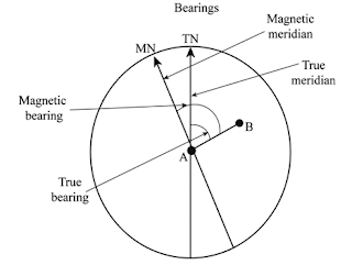
Differentiate between the following (2x 10) Permanent benchmark and temporary benchmark Permanent Bench Marks    These bench marks are established between G.T.S. bench marks by the Survey of India or other government agencies such as P.W.D., on clearly defined and permanent natural or cultural detail points such as isolated rocks culverts, kilometre stones, railway platforms, gate pillars of inspections houses, etc. Temporary Bench Marks   These are the reference points on which a day’s work is closed and from where levelling is continued next day in the absence of a permanent B.M. Their elevations are referred to as the reduced levels. Such bench marks should be carefully established on permanent detail points such as km stones, parapets, floor of verandahs, roots of old trees, etc. Their correct descriptions should invariably be written in level books. True and magnetic bearing True Bearing.   The horizontal angle between the true meridian and the survey line ...

Principles of Geoinformatics - short answer questions from AMIE exams (Winter 2020)

Image
Write short notes on (2.5 x 8 = 20 marks) Adjustment of Closed traverse When a closed traverse is plotted from the field measurements, the end station of a traverse generally does not coincide exactly with its starting station. This discrepancy is due to the errors in the field observations i.e. magnetic bearings and linear distances. Such an error of the traverse is known as a closing error or an error of closure. When the angular and linear measurements are of equal precision, graphical adjustment of the traverse may be made. This method is based on Bowditch’s rule . Corrections are applied to lengths as well as to bearings of the lines in proportion to their lengths. Let l = length of any leg Σ l = total length of the traverse Σ L = total error in latitude Σ D = total error in the departure δL = correction to the latitude of the leg δD = correction to the departure of the leg Then as per  Bowditch’s rule             Reverse Curve A curve that consis...