Principles of Geoinformatics - short answer questions from AMIE exams (Winter 2018)
Differentiate between the following (2 x 10)
Systematic errors and Accidental errors
- Systematic errors These are the errors that occur from well-understood causes and can be reduced by adopting suitable methods. For example, the error due to the sag of a tape supported at the ends can be calculated and subtracted from each measurement. However, the tape can be supported throughout its length at short intervals and the sag error may be reduced to a negligible quantity. It always has the same magnitude and signs so long as the conditions remain the same and such an error is called constant systematic error. Whereas, if the conditions change, the magnitude of the error changes and this is known as variable systematic error. A systematic error follows a definite mathematical or physical law and, therefore, a correction can always be determined and applied. lt| is also known as cumulative error.
- Accidental errors These are errors due to a combination of causes and are beyond the control of the surveyor. It can be a plus or minus. The calibration of a chain is an example of an accidental error.
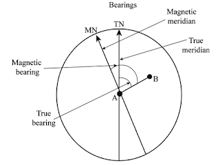
True bearing and Magnetic bearing
True Bearing. The horizontal angle between the true meridian and the survey line measured in a clockwise direction is called the true bearing of the line.
Magnetic Bearing. The horizontal angle which a survey line makes with the magnetic meridian is called magnetic bearing. It is not constant at a point but varies with laps of time.
Reciprocal ranging and Reciprocal levelling
Reciprocal Levelling
It is the operation of levelling in which the difference in elevation between two points is accurately determined by two sets of reciprocal observations. This method is very useful when the instrument cannot be set up between the two points due to an obstruction such as a valley, river, etc., and if the sights are much longer than are ordinarily permissible.
Gunter's chain and Engineers’ chain
Free needle method of traversing and Fast needle method of traversing
Free or Loose Needle Method
In this method, the linear measurements are done with the help of either chain or tape and the bearings are measured with the help of a compass. Both fore and back bearings of lines are observed at each station. The results obtained by this method are. in general, not that accurate as obtained by the following two methods.
Fast Needle Method
In this method, the linear measurements are made with the help of a chain or tape and the bearings are measured with the help of a theodolite whose telescope is inverted for alternate backward and forward readings. It may be noted that if the line of collimation is not properly adjusted, the included angles will be in error.
The advantage of this method is that the bearings are obtained directly. The work can thus be checked during its progress and the errors can be detected and rectified immediately. Also, the fieldwork is less cumbersome and the computations are simple as compared to the method of measuring angles.
Observation equation and Condition equation
Normal (observation) equation
An ‘observation equation’ is the symbolic equality of a quantity and its observed value, e.g., ∠A = 145°32'20'' , or ∠B + ∠C = 67°35'17''. The former value is observed by direct single measurement and the latter one is observed indirectly when simultaneous observations or conditions are involved.
Condition equation
An equation that expresses exactly certain relationships that must exist among related quantities. For example: In measuring the angles of a triangle, no condition exists until all three angles are measured. The condition equation will then express the condition that the three measured angles plus certain corrections must equal 180° plus the spherical excess of the triangle. The various condition equations set up in surveying are—angle equation, side equation, length equation, latitude equation, longitude equation, and azimuth equation.
Aerial photographs and topographic maps
Aerial photograph. These are the photographs obtained as a result of photography of ground from
the air with a camera mounted on an aircraft. The image of the ground photographed
is formed on the focal plane of the camera’s objective, where a sensitive film is
placed.
Topographic maps
The distinctive characteristic of a topographic map is the use of elevation contour lines to show the shape of the Earth's surface. Elevation contours are imaginary lines connecting points having the same elevation on the surface of the land above or below a reference surface, which is usually mean sea level. Contours make it possible to show the height and shape of mountains, the depths of the ocean bottom, and the steepness of slopes.
Near vertical photographs and Topographic maps
Near vertical photograph
It is normally very difficult to achieve a perfect vertical photograph due to the fact that the aircraft flies over the curved surface of the earth. The photographic axis, therefore, deviates from the vertical axis. If such a deviation is within the range of plus or minus 3⁰, the near-vertical aerial photographs are obtained. Any photograph with an unintentional deviation of more than 3⁰ in the optical axis from the vertical axis is known as a tilted photograph.
Topographic maps
The distinctive characteristic of a topographic map is the use of elevation contour lines to show the shape of the Earth's surface. Elevation contours are imaginary lines connecting points having the same elevation on the surface of the land above or below a reference surface, which is usually mean sea level. Contours make it possible to show the height and shape of mountains, the depths of the ocean bottom, and the steepness of slopes.
Triangulation and Traversing
Triangulation
When the area to be surveyed is of a considerable extent, triangulation is adopted. The entire area is divided into a network of triangles. Anyone side of any of the triangles so formed, is selected and is measured precisely. Such a line is called a baseline. All the angles in the network are measured with a transit. The lengths of the sides of all the triangles are then computed, from the measured length of the baseline and the observed corrected angles, using the sine formula.

Traversing
The word traverse means ‘passing across.’ In surveying, it means ‘determining the lengths and directions of consecutive lines.’
Crab and Drift


- The study material for AMIE/B Tech/Junior Engineer exams is available at https://amiestudycircle.com
- If you like the post please share your thoughts in the comment section


Comments